zaterdag 23 september 2017

More Havoc as Category 3 Maria Plows Northward

More Havoc as Category 3 Maria Plows Northward

September 22, 2017, 12:19 PM EDT

 
Above: Electricity poles and lines lay toppled in Humacao, in northeastern Puerto Rico, in the wake of Hurricane Maria on September 20, 2017. AP Photo/Carlos Giusti.
Hurricane Maria continued its destructive rampage on Friday morning, bringing torrential rains and high winds to the Dominican Republic and Turks and Caicos Islands. Heavy rains from the hurricane also continued to affect Puerto Rico and the Virgin Islands, and were spreading into the southeast Bahamas.
Satellite imagery on Friday morning showed that Maria remained well-organized, with a large area of very intense thunderstorms surrounding a huge 45-mile-diameter eye. Even though the eye had become cloud-filled, the Hurricane Hunters detected no change in Maria’s intensity, with the pressure holding nearly steady at 958 – 960 mb, and the surface winds maintaining a high-end Category 3 velocity, 125 mph. The Hurricane Hunters reported that the eyewall was open on the southwest side, likely because of moderately high wind shear of 15 – 20 knots, due to strong upper-level winds out of the southwest. This wind shear was keeping intensification of Maria in check.
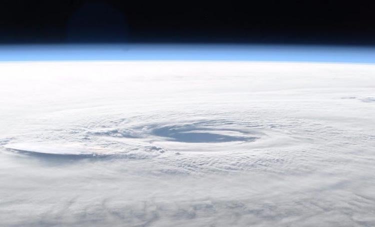
Hurricane Maria from Int'l Space Station, 9/21/2017
Figure 1. Hurricane Maria as seen on the morning of September 21, 2017, from the International Space Station. Image credit: Randy Bresnik.

Impact on Turks and Caicos Islands

Early on Friday, Maria passed about 35 miles east of Cockburn Town (population 3,700), the capital city of the Turks and Caicos Islands. Cockburn Town received a direct hit from the western (weaker) eyewall of Maria, and likely experienced major damage from a large storm surge and winds of at least Category 2 strength. Cockburn Town also received heavy damage from Hurricane Irma two weeks ago. Farther to the west, a personal weather station on Providenciales recorded a peak wind gust of 57 mph on Friday morning, when the center of Maria made its closest approach, about 100 miles to the east.

Impact on the Dominican Republic

Maria hit the northern Dominican Republic hard with torrential rains and high winds on Thursday evening and Friday morning, as the hurricane passed about 50 – 100 miles to the north. The storm killed two people and left one missingin the Dominican Republic, and knocked out power to over 140,000 customers, including the entire northern section. A peak wind gust of 64 mph was recorded at Punta Cana on the eastern tip of the Dominican Republic on Thursday morning, and peak winds of 37 mph, gusting to 40 mph occurred at Puerto Plata at 8 pm Thursday night. Intermittent heavy rain squalls from Maria will continue to affect the Dominican Republic during the day Friday.

Forecast for Maria

Models are in close agreement that Maria will continue moving north-northwest, gradually angling northward, on a rather slow trek through the Northwest Atlantic over the next several days. Strong wind shear of around 20 knots will be chipping away at Maria’s strength over the next day or two, and eventually Maria will encounter the cold wake left by Jose, so we can expect Maria to gradually weaken. NHC predicts that Maria will be a minimal Category 1 hurricane by Wednesday, located a couple of hundred miles east of the Outer Banks of North Carolina.
The 5-day cone of uncertainty lies just east of the Outer Banks, and about 5 – 10% of members of the GFS and European ensemble runs from 0Z Friday brought Maria into the Carolinas. These numbers have not increased since Thursday, and the consistent verdict among our top track models that Maria will remain offshore is a very good sign. Still, Maria is more than five days from its closest approach to the Outer Banks, and the latest 12Z Friday run of the GFS model predicted that Maria would come within 200 miles of the Outer Banks on Wednesday, compared to a 350 mile closest approach the model predicted in its 6Z Friday run. A landfall in North Carolina or the mid-Atlantic coast is still a possibility, though there's a more substantial chance that Maria will make landfall in the Canadian Maritimes, especially Labrador and Newfoundland, as a tropical storm or intense post-tropical cyclone. About a third of the Euro ensemble members from 0Z Friday showed Maria making landfall in the Maritimes. 
Rainfall from Maria in Puerto Rico through 9/21/2017
Figure 3. Estimated rainfall from Maria through 6 pm EDT Thursday, September 21, 2017. Image credit: NWS San Juan.

The aftermath of Maria, from Dominica to Puerto Rico

One of the strongest hurricanes ever to rampage through the Caribbean, Maria has inflicted billions of dollars in damage on places that may struggle to put the pieces back together. Considering the destruction from Maria, the hurricane’s death toll thus far is mercifully low— 15 in Dominica, 13 in Puerto Rico, 2 in Guadelope, and 2 in the Dominican Republic–although dozens remain missing in Dominica and some parts of Puerto Rico have yet to be heard from. Power and water are out across Dominica, and at least 90 percent of buildings have sustained some damage, with the east coast hit hardest, according to the Caribbean Disaster Emergency Management Agency (via ReliefWeb). All of the island’s crops are likely destroyed, says CDEMA. Aerial photos and tweeted images indicate widespread damage across St. Croix (one of the U.S. Virgin Islands), whose western end experienced some of Maria’s strongest winds. Fortunately, the damage on St. Croix appears less severe than on the Virgin Islands hit by Hurricane Irma, according to the Virgin Islands Daily News
In Puerto Rico, damage is still being assessed after flash flooding that continued through Thursday. It will be a daunting task to get the power back on across the territory. Even before Maria, Hurricane Irma had knocked out roughly 70 percent of the island’s grid. The head of the Puerto Rico Electric Power Authority told CNN that “the system has been basically destroyed” and that it could take up to six months to complete repairs. Puerto Rico’s power grid has been weakened by deferred maintenance, in part an outgrowth of manufacturing losses and mounting territorial debt that have left the power authority bankrupt. Moreover, as noted by Quartz, Puerto Rico’s grid is almost completely reliant on fossil fuels (mainly fuel oil), which provide 98% of electricity in Puerto Rico vs. 65% in the 50 U.S. states and just 2% in Costa Rica. In the wake of Hurricane Irma, some homes and communities in Florida with solar power were able to restore their electrical service before repairs to the larger grid were complete, according to Inside Climate News. The largest oil-fired power plants in Puerto Rico are in the south, notes the Los Angeles Times, and there may be heavy damage to the transmission lines that bring power to the north. Puerto Rico was declared a federal disaster zone on Thursday, which will enable residents and the local government to apply for assistance from FEMA. With any luck, the rebuilt power grid will be far more robust than the aging one was.
Life over the coming weeks—or months in some cases—will be a grueling ordeal for many Puerto Ricans, especially those who lack generators. Most of the island’s wireless cell sites have been knocked out, and the patchy grid will further complicate phone usage. Weather Underground’s 10-day outlook for San Juan has lows near 80°F and highs between 85°F and 90°F throughout the period. Very high dewpoints will put the heat index near or above 100°F each day. The risk of heat-related illness or death rises greatly when there is no relief from very high temperatures around the clock for multiple days.

Jose goes post-tropical at last

NHC is now in its third week of issuing advisories on the long-lived system that it reclassified as Post-Tropical Cyclone Jose on Thursday night. Jose’s 16.5 days as a tropical cyclone made it the seventh-longest-lived named storm in Atlantic records since the start of the satellite era (1966), according to Phil Klotzbach (Colorado State University). Jose came within just five days of the satellite-era record of 21.25 days held by Hurricane Ginger (1971).
As of 11 am EDT Friday, Jose was centered about 120 miles south-southeast of Nantucket, Massachusetts, drifting southwest at just 2 mph. Jose’s top sustained winds are down to 45 mph, and its showers and thunderstorms have become even more sparse, limited mainly to a few patches on its southwest side. A tropical storm warning remained in effect for the islands of far southeast New England. The area received its highest wind gusts yet from Maria on Thursday night, including 62 mph at Nantucket and Aquinna, MA and 61 mph on Block Island, RI. The rains are adding up as well: Nantucket had received 5.95” as of late Thursday, with light rain continuing Friday morning. Jose is expected to continue drifting westward, influenced in part by Maria, before degenerating into an open wave by early next week.
Jose, Maria, and potential TC in North Atlantic, 9/21/2017
Figure X. Dwarfed by Hurricane Maria and Post-Tropical Cyclone Jose (left), a small area of low pressure in the central North Atlantic (right) could become a tropical cyclone in the next several days. Image credit: RAMMB / CIRA @ CSU, via Philippe Papin (@pppapin).

Son of Lee:  A potential mini-spin-up in North Atlantic? 

Tropical Storm Lee dissipated last Monday, but we may see a tropical cyclone develop from some of its remnants over the next day or so. Philippe Papin (University at Albany/SUNY) called attention on Thursday night to a small spin-up along an elongated zone of low pressure extending north from Lee’s old center of circulation. Some banding was evident with showers and thunderstorms around this feature on Friday morning, noted Papin. ASCAT scatterometer data showed a circulation with 20-25 mph winds centered around 29°N, 49°W, heading slowly northward. Wind shear is around 10 – 15 knots in the area of this disturbance, but a large zone of weaker shear lies just to the north, and SSTs of around 28°C (84°F)—about 1°C above average—are more than adequate for development. In a special update to its 8 am EDT Tropical Weather Outlook, NHC gave this feature a 30 percent chance of becoming at least a tropical depression by Sunday and a 40 percent chance by Wednesday. Given the favorable pre-conditions, we’d put those odds a bit higher: 50 percent by Sunday and 70 percent by Tuesday. If this system develops and is deemed by NHC to have roots in the remnants of Lee, it will take the name Lee; otherwise, it will be named Nate.

How you can help with hurricane relief

The Portlight.org disaster relief charity, founded and staffed by members of the wunderground community, is responding to Hurricane Maria in Puerto Rico and the U.S. Virgin Islands, and is continuing its efforts for victims of Hurricane Harvey and Hurricane Irma.
USVI Recover is the official site for recovery efforts in the U.S. Virgin Islands from Hurricane Irma and Hurricane Maria. The nonprofit Community Foundation of the Virgin Islands (CFVI) has established the Fund for the Virgin Islands, with 100% of donations benefiting those in crisis.
The New York Times has a list of local, national, and global charities providing relief for those affected by Hurricane Maria. Another comprehensive list can be found at weather.com, which notes: “Giving money to vetted and established relief agencies [as opposed to donating goods] is ‘always the best way to help,’ according to the U.S. Agency for International Development.”
Jeff Masters co-wrote this post.
The Weather Company’s primary journalistic mission is to report on breaking weather news, the environment and the importance of science to our lives. This story does not necessarily represent the position of our parent company, IBM.

 author image

Bob Henson

WU meteorologist Bob Henson, co-editor of Category 6, is the author of "Meteorology Today" and "The Thinking Person's Guide to Climate Change." Before joining WU, he was a longtime writer and editor at the University Corporation for Atmospheric Research in Boulder, CO.


Hurricane Harvey, 25,000-Year Storm

Hurricane Harvey, 25,000-Year Storm: Enhanced or Caused by Climate Change?

Friday, September 22, 2017 By Bruce MeltonClimate Discovery | News Analysis 
Members of the South Carolina’s Helicopter Aquatic Rescue Team (SC-HART) perform rescue operations in Port Arthur, Texas, August 31, 2017. The SC-HART team consists of a UH-60 Black Hawk helicopter from the South Carolina Army National Guard with four Soldiers who are partnered with three rescue swimmers from the State Task Force and provide hoist rescue capabilities. Multiple states and agencies nationwide were called to assist citizens impacted by the epic amount of rainfall in Texas and Louisiana from Hurricane Harvey. (U.S. Air National Guard photo by Staff Sgt. Daniel J. Martinez)Members of the South Carolina's Helicopter Aquatic Rescue Team (SC-HART) perform rescue operations in Port Arthur, Texas, August 31, 2017. The SC-HART team consists of a UH-60 Black Hawk helicopter from the South Carolina Army National Guard with four Soldiers who are partnered with three rescue swimmers from the State Task Force and provide hoist rescue capabilities. Multiple states and agencies nationwide were called to assist citizens impacted by the epic amount of rainfall in Texas and Louisiana from Hurricane Harvey. (Photo: US Air National Guard / Staff Sgt. Daniel J. Martinez)
It was a 25,000-year storm. Its area of 24-inch rainfall was 50 to 100 times greater than anything previously recorded in the lower 48. Up to a million cars may have been flooded. In Harris County alone, 136,000 homes were flooded. Yet the official word from academia on Hurricane Harvey was that it "may have been enhanced" by climate change. When are we going start using professional judgement like doctors and engineers use to keep us safe, instead of the absolutes of certainty with science? Because of certainty in science, we cannot admit that Hurricane Harvey and other extraordinary weather extremes like Harvey were caused by climate change. Not only are we are exposing our culture to grave risk, but by not using professional judgement to make this call, we perpetuate climate pollution reform inaction that has solely created this great risk.
Hurricane Harvey Total Rainfall: The black dashed line is approximate area of 24 inch rainfall. the blue and red dots are rain fall reporting stations. In excess of 15,000 square miles received about two feet of rain or more. Hurricane Harvey Total Rainfall: The black dashed line is approximate area of 24 inch rainfall. the blue and red dots are rain fall reporting stations. In excess of 15,000 square miles received about two feet of rain or more. "We can't tell if this particular weather event was caused by climate change or not." This is one of the most dangerous climate science statements in history. It comes from certainty in statistics and it defines how scientists speak of their findings. There will always be a chance that a weather event could have occurred in either our old climate or our new climate. Generally, if there is a 1 in 20 chance, or even a 1 in 10 chance that something is not 100% for sure, we get this dangerous quote from scientists. The concept is based on an event that happens five or ten percent of the time and is directly related to the terms from the Intergovernmental Panel on Climate Change (IPCC) of "extremely likely (5%)" and "very likely (10%)". It is this "certainty" in science that is getting us into trouble. 
Harvey had a one in 25,000 chance of occurring in any given year -- in our old climate. Therefore, Harvey should happen once every 25,000 years. Sorting this out with science takes time that we simple do not have.
Regardless of the risks, science must adhere to principles of "certainty." But doctors and engineers are not bound by certainty. Harvey, and Sandy, Ike, Charlie all those record breaking Pacific Cat 5 cyclones recently, these are not normal hurricanes. Though the science says they will get bigger and more extreme with warming, why don't climate scientists just come out and say the obvious?  
Take Harvey for example. Those first reports of Harvey being a 1,000 year storm were obviously not correct. This is obvious to me, a hydrologist for 30 years. But everyone else must rely on what the media says.  n this case, a very well credited sicentists atthe University of Wisconsin used the tools available  to evaluate the worst 24 hour rainfall period of Harvey, that proved to be a 1,000-year storm, and then that went rogue. This 1,000-years storm represented an overnight "core dump" or rainfall. This is what a dying, land bound, stalled out hurricane does; it dumps all of its rain in the central core, at night. Houston saw three of these core dumps on three successive nights. But three 1,000-year storms ion three successive nights is not a 1,000-year storm. As we know now from the good work of the folks at Metstat, this entire event 120 hours of rain, was a 25,000-year storm.
What doctors and engineers do to keep us safe is they use professional judgement. They take the certainty of science and apply it to life using risk to gauge whether or not action is demanded. If the uncertainty is high, but the risk is grave, say with cancer, or auto crash mortality, the decision is simple. Treat the risk as if it was a sure thing.  If the risk is high enough with professional judgement, the event becomes certain enough for action to be taken. Do we wait and see if the projections of climate changes are scientifically certain before we act, or do we use professional judgement? 
The U.S. Continental 24-hour rainfall record was set in Alvin in 1979 during tropical storm Claudette. Claudette’s rains of greater than 24 inches covered 400 to 500 square miles. David Roth, Weather Prediction Center, Camp Springs, Maryland National Oceanic and Atmospheric Administration, NOAA.The US Continental 24-hour rainfall record was set in Alvin in 1979 during tropical storm Claudette. Claudette's rains of greater than 24 inches covered 400 to 500 square miles. David Roth, Weather Prediction Center, Camp Springs, Maryland National Oceanic and Atmospheric Administration, NOAA.

 Harvey's Climate Change Certainty

A warmer atmosphere holds more water vapor. A warmer ocean has more energy for a storm's development. Warmer water evaporates faster, putting even more moisture in the atmosphere. Deeper ocean warming now present in the Gulf of Mexico creates less cooling of the ocean surface from mixing caused by hurricane wind and waves, which allows more heat to be transferred to the atmosphere. And dynamics: dynamics are those processes like when we look into a pot of water on the stove and see convection, or warmer water rising from the bottom of the pot. As our average air temperature increases, rising air moves faster.
When moist air rises, because the temperature falls with altitude, the moisture condenses into clouds. This condensation releases heat, which makes the air rise even faster, allowing more moisture to condense faster, releasing heat even faster. This is the hurricane heat engine. Climate change is like steroids for hurricanes.
In other words, climate change is a nonlinear process.  That is, a little warming does not create a little more hurricane, it creates a lot more, like a population explosion or an avalanche. Climate change is almost exclusively a nonlinear thing. A little warming puts a lot more energy in the weather.
The most extreme Cat 4 and Cat 5 hurricanes have already been shown to be increasing in strength and numbers, and are expected to double in numbers by century's end and total hurricane cumulative energy to increase by 20 percent -- based on scientific certainty. The Intergovernmental Panel on Climate Change (IPCC) in their 2013 report says there has been, "a virtually certain increase in the frequency and intensity of the strongest tropical cyclones since the 1970s in that region [the Atlantic basin]." They are referring here to Cat 4 and Cat 5 storms.
Also based on scientific certainty, Antarctica was not supposed to begin losing ice until after 2100 (IPCC 2007.)
Amelia’s 24 inch rains covered 500 to 600 square miles. David Roth, Weather Prediction Center, Camp Springs, Maryland National Oceanic and Atmospheric Administration, NOAA.Amelia's 24 inch rains covered 500 to 600 square miles. David Roth, Weather Prediction Center, Camp Springs, Maryland National Oceanic and Atmospheric Administration, NOAA.As of the 2013 IPCC report, Antarctica has now begun to lose ice (nearly as much as Greenland.) It was not because Antarctica suddenly began losing ice; the first publishing on Antarctic ice loss was in 1996. The reason is scientific certainty. We knew all along that Antarctica was losing ice, but the statistical certainty just wasn't there. Like, we know the Russians helped Trump win the election, but not enough is known yet to send people to prison.  
It is because of this certainty characteristic of science that virtually every climate impact we are seeing today is happening ahead of schedule: Arctic sea ice loss, Gulf Stream shutdown, beach erosion, polar subsea methane venting, high altitude and high latitude ecosystem collapse from insect attack, and the flip of Amazon from carbon sink to carbon source. All are happening decades to a century or more ahead of schedule, because scientific certainty could not say for sure that these things would happen as they have been happening, when these things were first published.

Harvey, the Jet Stream, the Polar Vortex and the Jelly Roll

The jet stream is a river of air flowing around the earth that is formed by the earth's rotation. Embedded within the jet stream are waves similar to the "haystack" waves that form in river rapids. They are called Rossby waves in meteorology. These waves "pick up" the jet stream and the two interact with one another creating meanders that push cold fronts and weather systems around the planet. So literally, these meanders in the jet stream move our weather west to east across the planet, following the jet stream's north/south meanders. 
Hadley Cells have expanded over Texas. Where the air in the Hadley Cells descends, steering currents are weak. Image from: COMET Program, a part of the University Corporation for Atmospheric Research's (UCAR's) Community Programs (UCP) and is sponsored by NOAA's National Weather Service (NWS).
Hadley Cells have expanded over Texas. Where the air in the Hadley Cells descends, steering currents are weak. Image from: COMET Program, a part of the University Corporation for Atmospheric Research’s (UCAR’s) Community Programs (UCP) and is sponsored by NOAA’s National Weather Service (NWS).Hadley Cells have expanded over Texas. Where the air in the Hadley Cells descends, steering currents are weak. Image from: COMET Program, a part of the University Corporation for Atmospheric Research's (UCAR's) Community Programs (UCP) and is sponsored by NOAA's National Weather Service (NWS).For about ten years now, we have known that these Rossby waves slow when Earth warms. The slowing is caused by the difference in temperature between the tropics and the poles; this is called arctic amplification where the poles warm more than the rest of the planet. It is these Rossby waves that researchers headed by Michael Mann form Penn State, and including the German Academy of Sciences, University of Minnesota at Duluth, and the University of Amsterdam, have published about in a continuing line of diverse research findings from across the globe. These findings reveal observations of slowing and stalling of the jet stream's march across the planet because of warming. This new work adds to the already established body of research and increases the "certainty" that events like hurricane Harvey were a product of climate change.
The far advanced northern location of the jet stream too, a condition created by expansion of subtropical circulation cells (Hadley cells) is also a part of the puzzle.  These Hadley cells exist on either side of the equator and wrap around earth like a giant jelly roll. They are caused by hot air rising in the tropics, flowing north in the upper atmosphere and descending somewhere at the boundary of the subtropics -- right over Texas. The position of Hadley cells is part of what determines where the jet stream flows around the earth. With expanded Hadley cells, the jet stream sets up farther north. The farther north the jet stream is, the less likely steering currents will pick up a tropical system and move it along. Riechler summarized the available work on expansion of Hadley Cells as an indicator of climate change and showed a 1.4 degree increase northward in the northern edge of the Hadley Cells per decade since 1979. This "shift" is nearly 400 miles.
Tropical Storm Allison in 2001 was the 17th most costly catastrophe in the US produced 30 to 40 inches of rain and $11.9 billion in damages. The area of 24″ rainfall was about 600 square miles.
Tropical Storm Allison in 2001 was the 17th most costly catastrophe in the U.S. produced 30 to 40 inches of rain and $11.9 billion in damages. The area of 24″ rainfall was about 600 square miles.Tropical Storm Allison in 2001 was the 17th most costly catastrophe in the US produced 30 to 40 inches of rain and $11.9 billion in damages. The area of 24″ rainfall was about 600 square miles.The slowing and stalling of weather systems caused by all these things has been attributed to drought and flood in recent decades. Most notably, Hurricane Sandy's infamous left turn into New York City and New Jersey was caused because of a stalled high pressure system over Greenland. The "left turn" made by Sandy had literally never occurred before, since records began being kept. The big Texas and Oklahoma drought in 2011 and the recent drought in California were all impacted by stalled Rossby waves.
Stalls are not new to hurricanes, but five day stalls are pretty crazy. A normal stall is a day or maybe two. Longer stalls have happened and these are responsible for the heaviest rainfall totals we have recorded. Hurricanes generally though, tend to move along. So with normal hurricane rain math of 10 inches a day, a couple of days stall give us 20 to 30 inches. Stall for two more days and we see fifty inches. 
As an aside, the polar vortex is another part of this discussion that is related, that we hear about often in winter with blizzards. The polar vortex is simply a meandering, relatively tightly spinning area of air at the poles caused because our world is round and air flows around it because it spins. The polar vortex wanders around in the arctic like a spinning top wobbles, drunkenly and naturally. When Rossby waves slow, the polar vortex wobble increases, pulling polar air farther south as the wobbles meander southward with the increasing wobbliness. You can see the polar vortex wobbling about in the NASA video above.

Extreme Extremes

The strongest hurricane (by wind speed) ever to hit the US at the time, creating the biggest storm surge ever recorded, was Camille in 1969 with a record 22 foot surge. It struck virtually the exact same spot as Katrina, but Katrina in 2005 had a surge of 28 feet. Hurricane Sandy's record shattering impacts in 2012 were caused after Sandy had been downgraded to a tropical storm just before it made landfall. Not even a hurricane, it carried a storm surge of 14 feet, whereas a Category 1 hurricane has a normal storm surge of 4 to 5 feet (a Cat 2 is 6 to 8 feet, Cat 3 is 9 to 12, and a Cat 4 has a normal surge of 13 to 18 feet.) Ike, at Galveston in 2008, was a Cat 2 storm with a 22 foot storm surge. 
Four-foot rainfall events of note are rare, but two of them have happened in Texas; Amelia in 1978 and Claudette in 1979. Amelia had the all-time North American continent rainfall event record at 48 inches and Claudette had the all-time 24-hour rainfall record of 45 inches. Seeing as both of these storm happened in Texas, one might say Texas is a little bit prone to these events which would likely be a pretty valid statement.
Enhancement of the stall is happening now because of two different things: Rossby waves and Hadley cells.  Enhancement of rainfall quantity is happening in four different ways: increased moisture capacity, warmer ocean, deeper warming, and increased dynamics. If the enhancement was just a little bit, the answer to the question of "caused" or "enhanced" would not be so important.
Another clue as to the responsibility of climate change lies in the extreme extent of the rains and this consideration is profound. Hurricanes stalls are not rare. Both the 24-hour and total event rainfall records in the US were caused by stalled tropical systems. Hurricane Amelia and Tropical Storm Claudette created 24 inches of rainfall over an area in the mid hundreds of square miles each. The vast difference with Harvey is that he created rainfall in excess of 24 inches in an area in of about 18,000 square miles. The area of 24 inch rainfall covered by Harvey was 36 to 45 times more than the previous all-time records.

Enhanced or Caused?

Was Harvey "enhanced" or "caused" by climate change? Ask a scientist and certainty compels them to say "enhanced." But would Harvey have been such an incredible disaster if it had of not stalled, or stalled less? Did the climate change slowed Rossby waves and the expanded jelly roll Hadley Cells cause four feet of rain in Houston, when a normally hurricane would have created two, three, or even four days less rain?
There is a distinct line between a weather catastrophe and just another weather event. Is it fair to say that climate change only "enhanced" this event when there is the distinct possibility that it would not have occurred at all without the stall, or the increased moisture in the warmer atmosphere, or the extra warm water, or the extra deep extra warm water, or the extra dynamics? 
It is the astonishing increase in area of massive rainfall that really holds Harvey apart from storms that were simply "enhanced" by climate change. How many more of these events will we have to endure before we begin to rightly call them as they are? 
If you ask climate scientist, or a media person or elected leader, or a plain old scientists who watches the news and listens to what the scientists say, we know what the answer will be. When are we going to begin using professional judgement to communicate the risk that current warming has already created to our society? That yes, current warming is very dangerous and we don't have to wait for 1.5 or 2 degrees C of warming for it to become dangerous. When too, are we going to change our climate culture from one that only seeks to limit warming to some level that we see now is far too dangerous, rather than returning our climate to a safe and healthy state?
Harvey was definitely "caused" by climate change. Without climate change, Harvey would have just been another 25 inch tropical system in Houston, And this supposition assumes that the stall would have happened anyway. Without the stall, because the storm hit 150 miles away, Houston could have been left high and dry with hardly a drop of rain.
This piece was reprinted by Truthout with permission or license. It may not be reproduced in any form without permission or license from the source.

BRUCE MELTON

Bruce Melton is a professional engineer, environmental researcher, filmmaker, author and CEO of the Climate Change Now Initiative in Austin, Texas. The Climate Change Now Initiative is a nonprofit outreach organization reporting the latest discoveries in climate science in plain English. Information on his book, Climate Discovery Chronicles, can be found along with more climate change writing, climate science outreach and critical environmental issue documentary films at ClimateDiscovery.org. Images copyright Bruce Melton and the Climate Change Now Initiative except where referenced otherwise.

Dutch Government Subsidizes White Helmets Terrorists

'They don't care about us': Syrians on White Helmets' true agenda


John Pilger: Killing: The American Way


Killing: The American Way

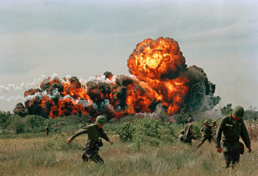
A napalm strike during the Vietnam War. (manhahi / CC BY 2.0)
One of the most hyped “events” of American television, “The Vietnam War,” has started on the PBS network. The directors are Ken Burns and Lynn Novick. Acclaimed for his documentaries on the Civil War, the Great Depression and the history of jazz, Burns says of his Vietnam films, “They will inspire our country to begin to talk and think about the Vietnam War in an entirely new way.”
In a society often bereft of historical memory and in thrall to the propaganda of its “exceptionalism,” Burns’ “entirely new” Vietnam War is presented as “epic, historic work.” Its lavish advertising campaign promotes its biggest backer, Bank of America, which in 1971 was burned down by students in Santa Barbara, California, as a symbol of the hated war in Vietnam.
Burns says he is grateful to “the entire Bank of America family,” which “has long supported our country’s veterans.” Bank of America was a corporate prop to an invasion that killed perhaps as many as 4 million Vietnamese and ravaged and poisoned a once-bountiful land. More than 58,000 American soldiers were killed, and around the same number are estimated to have taken their own lives.
I watched the first episode in New York. It leaves you in no doubt of its intentions right from the start. The narrator says the war “was begun in good faith by decent people out of fateful misunderstandings, American overconfidence and Cold War misunderstandings.”

The dishonesty of this statement is not surprising. The cynical fabrication of “false flags” that led to the invasion of Vietnam is a matter of record—the Gulf of Tonkin “incident” in 1964, which Burns promotes as true, was just one. The lies litter a multitude of official documents, notably the Pentagon Papers, which the great whistleblower Daniel Ellsberg released in 1971.
There was no good faith. The faith was rotten and cancerous. For me—as it must be for many Americans—it is difficult to watch the film’s jumble of “red peril” maps, unexplained interviewees, ineptly cut archive and maudlin American battlefield sequences.
In the series’ press release in Britain—the BBC will show it—there is no mention of Vietnamese dead, only Americans. “We are all searching for some meaning in this terrible tragedy,” Novick is quoted as saying. How very post-modern.
All this will be familiar to those who have observed how the American media and popular culture behemoth has revised and served up the great crime of the second half of the twentieth century—from “The Green Berets” and “The Deer Hunter” to “Rambo”—and, in so doing, has legitimized subsequent wars of aggression. The revisionism never stops, and the blood never dries. The invader is pitied and purged of guilt, while “searching for some meaning in this terrible tragedy.” Cue Bob Dylan: “Oh, where have you been, my blue-eyed son?”
I thought about the “decency” and “good faith” when recalling my own first experiences as a young reporter in Vietnam: watching hypnotically as the skin fell off Napalmed peasant children like old parchment, and the ladders of bombs that left trees petrified and festooned with human flesh. General William Westmoreland, the American commander, referred to people as “termites.”
In the early 1970s, I went to Quang Ngai province, where in the village of My Lai, between 347 and 500 men, women and infants were murdered by American troops (Burns prefers “killings”). At the time, this was presented as an aberration: an “American tragedy” (Newsweek ). In this one province, it was estimated that 50,000 people had been slaughtered during the era of American “free fire zones.” Mass homicide. This was not news.
To the north, in Quang Tri province, more bombs were dropped than in all of Germany during the Second World War. Since 1975, unexploded ordnance has caused more than 40,000 deaths in mostly “South Vietnam,” the country America claimed to “save” and, with France, conceived as a singularly imperial ruse.
The “meaning” of the Vietnam war is no different from the meaning of the genocidal campaign against the Native Americans, the colonial massacres in the Philippines, the atomic bombings of Japan, the leveling of every city in North Korea. The aim was described by Colonel Edward Lansdale, the famous CIA man on whom Graham Greene based his central character in “The Quiet American.”
Quoting Robert Taber’s “The War of the Flea,” Lansdale said, “There is only one means of defeating an insurgent people who will not surrender, and that is extermination. There is only one way to control a territory that harbors resistance, and that is to turn it into a desert.”
Nothing has changed. When Donald Trump addressed the United Nations on Sept. 19—a body established to spare humanity the “scourge of war”—he declared he was “ready, willing and able” to “totally destroy” North Korea and its 25 million people. His audience gasped, but Trump’s language was not unusual.
His rival for the presidency, Hillary Clinton, had boasted she was prepared to “totally obliterate” Iran, a nation of more than 80 million people. This is the American Way; only the euphemisms are missing now.
Returning to the U.S., I am struck by the silence and the absence of an opposition—on the streets, in journalism and the arts, as if dissent once tolerated in the “mainstream” has regressed to a dissidence: a metaphoric underground.
There is plenty of sound and fury at Trump the odious one, the “fascist,” but almost none at Trump the symptom and caricature of an enduring system of conquest and extremism.
Where are the ghosts of the great anti-war demonstrations that took over Washington in the 1970s? Where is the equivalent of the Freeze Movement that filled the streets of Manhattan in the 1980s, demanding that President Reagan withdraw battlefield nuclear weapons from Europe?
The sheer energy and moral persistence of these great movements largely succeeded; by 1987 Reagan had negotiated with Mikhail Gorbachev an Intermediate-Range Nuclear Forces Treaty (INF) that effectively ended the Cold War.
Today, according to secret NATO documents obtained by the German newspaper, Süddeutsche Zeitung, this vital treaty is likely to be abandoned as “nuclear targeting planning is increased.” The German Foreign Minister Sigmar Gabriel has warned against “repeating the worst mistakes of the Cold War. … All the good treaties on disarmament and arms control from Gorbachev and Reagan are in acute peril. Europe is threatened again with becoming a military training ground for nuclear weapons. We must raise our voice against this.”
But not in America. The thousands who turned out for Senator Bernie Sanders’ “revolution” in last year’s presidential campaign are collectively mute on these dangers. That most of America’s violence across the world has been perpetrated not by Republicans, or mutants like Trump, but by liberal Democrats, remains a taboo.
Barack Obama provided the apotheosis, with seven simultaneous wars, a presidential record, including the destruction of Libya as a modern state. Obama’s overthrow of Ukraine’s elected government has had the desired effect: the massing of American-led NATO forces on Russia’s western borderland through which the Nazis invaded in 1941.
Obama’s “pivot to Asia” in 2011 signaled the transfer of the majority of America’s naval and air forces to Asia and the Pacific for no purpose other than to confront and provoke China. The Nobel Peace Laureate’s worldwide campaign of assassinations is arguably the most extensive campaign of terrorism since 9/11.
What is known in the U.S. as “the left” has effectively allied with the darkest recesses of institutional power, notably the Pentagon and the CIA, to see off a peace deal between Trump and Vladimir Putin and to reinstate Russia as an enemy, on the basis of no evidence of its alleged interference in the 2016 presidential election.
The true scandal is the insidious assumption of power by sinister war-making vested interests for which no American voted. The rapid ascendancy of the Pentagon and the surveillance agencies under Obama represented an historic shift of power in Washington. Daniel Ellsberg rightly called it a coup. The three generals running Trump are its witness.
All of this fails to penetrate those “liberal brains pickled in the formaldehyde of identity politics,” as Luciana Bohne noted memorably. Commodified and market-tested, “diversity” is the new liberal brand, not the class people serve regardless of their gender and skin color: not the responsibility of all to stop a barbaric war to end all wars.
“How did it fucking come to this?” says Michael Moore in his Broadway show, “Terms of My Surrender,” a vaudeville for the disaffected set against a backdrop of Trump as Big Brother.
I admired Moore’s film, “Roger & Me,” about the economic and social devastation of his hometown of Flint, Michigan, and “Sicko,” his investigation into the corruption of health care in America.
The night I saw his show, his happy-clappy audience cheered his reassurance that “we are the majority!” and calls to “impeach Trump, a liar and a fascist!” His message seemed to be that had you held your nose and voted for Hillary Clinton, life would be predictable again.
He may be right. Instead of merely abusing the world, as Trump does, the Great Obliterator might have attacked Iran and lobbed missiles at Putin, whom she likened to Hitler: a particular profanity given the 27 million Russians who died in Hitler’s invasion.
“Listen up,” said Moore, “putting aside what our governments do, Americans are really loved by the world!”
There was a silence.
John Pilger, an Australian who lives in the United Kingdom, is a prize-winning journalist and documentary filmmaker. His website is johnpilger.com.